Andhra Pradesh/SotM
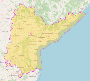
Andhra Pradesh is a state on the east coast of southern India. It is the seventh-largest state spreading over an area of 162,970 km2 (62,920 sq mi). It is also the tenth-most populous in the country. The initial steps towards mapping Andhra Pradesh as a geographical boundary happened on 12th Feb 2012, with the first clean boundary mapped by 12 December 2012.
Apart from these individual contributions, team based efforts also contributed to map making in Andhra Pradesh. Notable among these were RMSI team contribution of health care facilities data. Coordinate Me 2024 contest, mapping by Ola and Amazon teams apart from some HOT teams. This State of the Map (SotM) article presents the progress, community, and specific use cases of OpenStreetMap (OSM) within Andhra Pradesh focusing on community growth, mapping data challenges, and local initiatives. As this is the first report of its kind, India level initiatives are also mentioned, before the state level initiatives to give context.
Preamble
Andhra Pradesh is a state of India on its east coast sharing borders with Tamil Nadu, Karnataka, Telangana, Chhattisgarh Odisha and Bay of Bengal. Yanam, part of Union Terriory Pondicherry is an enclave of the state. It was formed in 1956 by merger of Andhra state, with Telangana part of Hyderabad State. In 2014, it got bifurcated and became the state of Andhra of 1953, with minor deviations.
It is the seventh-largest state and the tenth-most populous in the country. Telugu, one of the classical languages of India, is the most widely spoken language in the state, as well as its official language. Amaravati is the state capital, while the largest city is Visakhapatnam. Andhra Pradesh shares borders with Odisha to the northeast, Chhattisgarh to the north, Karnataka to the west, Tamil Nadu to the south, Telangana to northwest and the Bay of Bengal to the east. It has the longest coastline in India (aerial distance between extreme ends) at about 1,000 kilometres (620 mi). It has an area of 162,970 km2 (62,920 sq mi). Based on the 2011 Census of India, the population of Andhra Pradesh is 49,577,103, with a density of 304/km2 (790/sq mi). The rural population accounts for 70.53%, while the urban population accounts for 29.47%.
The Eastern Ghats are a major dividing line separating coastal plains and peneplains in the state's geography. The Eastern Coastal Plains comprise the area of coastal districts up to the Eastern ghats as their border along the Bay of Bengal, with variable width. These are, for the most part, delta regions formed by the Krishna, Godavari, and Penna rivers. The state has five different soil types with the majority soil types being red lateritic and black soil types. Most of the coastal plains are put to intensive agricultural use. The Kadapa basin, formed by two arching branches of the Eastern ghats, is a mineral-rich area. Borra Caves, created millions of years ago by water activity and the country's second-longest cave system, the Belum Caves are in the state. The state has several beaches in its coastal districts, such as Rushikonda, Mypadu, and Suryalanka.
Andhra Pradesh hosts over 50 notified SEZs, spanning sectors like IT/ITES, pharmaceuticals, multi-product, biotechnology, and textiles, with a focus on export-oriented growth. Key operational examples include: Visakhapatnam Special Economic Zone and Sri City.
Mapping environment till 2015
Though OpenStreetMap was founded in 2004, early attempts at promoting it in India refer to 2007 efforts of Indian mapper Arun in Chennai.[1] [2] DataMeet which was started on January 26th 2011 by a handful of data enthusiasts as a google group for people working with data. The group organised Open DataCamp events starting from 2012 to explore the larger issues. It became a source for open data over the years.[3]. Availability of satellite images from 2010 might have helped accelerate the mapping activities.
During the Wiki conference India in Mumbai held during 18-20 November 2011, the OSM became to known wider section of volunteer Wikipedians.[4] Around 2011, Railway lines were starting to be mapped. National Data Sharing and accessibility Policy - 2012 of Government of India released on 9 February 2012, gave a fillip to mapping efforts, as SOI topo sheets were released under OGDL. Like the foreigners who took up the cause of Indian languages in 19th century, few foreign volunteers initially contributed to mapping India on OpenStreetMap.
The boundary was initiated on 12 Feb 2012 by laufkaefer. The mapping was subjected to redaction due to copyright update of OSM on 20 July 2012. The first clean boundary was mapped by 12 December 2012 by indigomc(overpass query,Changeset 14394670). As part of India level mapping, national highways in Andhra Pradesh were initiated around 2017. While efforts to map villages might have started earlier, large scale mapping picked up speed in 2019 with the availability of Bhuvan. Towards close of 2019, language activity in OSM got a major push with the release of mandals(sub-districts) with Telugu labels.[5]
Mapping environment after 2015
Launch of Interactive Wikimedia maps in 2018 helped increase the activity on OpenStreetMap and Wikipedia.[6] On 15 February 2021, the Government of India announced changes to the country's mapping policy which frees up lot of earlier restrictions related to mapping by individuals and organisations.[7] In 2024, addition of Telugu labels with simultaneous wikidata/wikipedia id's helped improve the mapping accuracy as part of Coordinate Me 2024 contest.[8] In 2025, additional focus on quality assurance using PMGSY data, helped improve the count of villages with wikidata and Telugu name tags to about 13000, which is close to the number of gram panchayats or revenue villages.
Community Status
Apart from individual contributors from India and rest of the world, several organised editing teams from private sector (Ola, Apple) contribute to mapping highways. Non profit HOTOSM, contributed to mapping through a project to aid Andhra Pradesh 2024 flood relief). The active contributor or the top contributor data is not easily available as the stats tool from Pascal does not give state/province wise breakdown as of now. The enhancement to support province level statistics will be of great help to large countries such as India, US etc. Telegram channel for Andhra Pradesh (@osmandhra) has 102 members at the end of the year. Swecha, Andhra Pradesh team organised several educational events across Andhra Pradesh during 2024 and 2025. Considering the activity on OSM Telegram channel and also discussions on the changesets, most active contributors are estimated to be between 5-10.
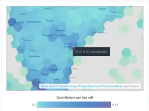
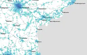
An analysis using OhsomeNow Stats for amenitities + 16 other items reveals that 3702 contributors worked for an area around Vijayawada. Link to Ohsome Stats dashboard.
Community events
First India/Bangalore community meetup happened in 2008 at IIM, Bangalore.[9] First mapathon to develop community happened in Bangalore in March 2015. SoTA asia happened in Bangalore, India durng 17-18 November 2018.[10]
Off-line events
6 offline events in 2024, 3 offline events in 2025 took place in which 188 and 150 participated respectively.
| Title | Type | Date | Organisers | Participants | Place | Links |
|---|---|---|---|---|---|---|
| OSM on Mobile workshop with OsmAnd at ANITS Vizag | Educational Session and Field Mapping | 2015-06-16 | OSGeo India, Swecha | 200 | ANITS Engineering College, Visakhapatnam | post |
| Workshop and field mapping with OsmAnd and ODK | Educational Session and Field Mapping | 2017-02-27 | OSGeo India, Swecha | 60 | Andhra University, Visakhapatnam | post |
| OSM intro and hands on mapping activity during Freedom Fest at MVGR College 2019 | Educational Session | 2019-09-22 | MVGR GLUG, Swecha AP | 50 | MVGR Engineering College, Vizianagaram | |
| Mapathon at PVP Siddhartha and KL Universities | Educational Session | 2024-02-07 | Swecha AP | 100+ students | Vijayawada | |
| OSM Vizag Mapping Party | Mapping Party | 2024-02-11 | Swecha AP | 10 | Central Park, Vizag | |
| KLGLUG Social Internship - Field mapping for OSM with EveryDoor + Wikimedia Commons + Mapillary | Field Mapping | 2024-07 | KL GLUG, Swecha AP | 40 | In respective villages of students | blog post Photos |
| KL University, Vijayawada OSM 20th Anniversary Mapping Party | Mapping Party | 2024-08-09 | KL GLUG, Swecha AP | 15 | KL University GLUG, Vijayawada | Photos |
| Bangalore community | Informal/Lunch meetup | 2024-07-27 | Bangalore community | 8 | Hotel in Bangalore | |
| Map making workshop for kids | Map making | 2024-12-08 | Swecha AP | 15 | Tadepalli, Vijayawada | Photos |
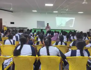
| Three day mapping workshop at Vijaya Institute of Technology for Women with id, EveryDoor, and Mapillary | Educational Session and Field Mapping | 2025-07-10 to 12 | Swecha AP | 100+ | Vijaya Institute of Technology for Women, Vijayawada | Blog post and photos |
| FOSS conference | Conference stall | 2025-09-20 & 21 | Bangalore | 10 | Nimhans Convention Centre, Bengaluru | |
| OSM Introduction workshop | Educational Session | 2025-10-09 | KL GLUG, Swecha AP | 40 | KL University GLUG, Vijayawada |
Online
Two online education events took place in 2024 with participation of 15 people.
| Title | Type | Date | Organisers | Participants | Links |
|---|---|---|---|---|---|
| An online session on introducing OpenStreetMap to Wikipedians | Educational Session | 2024-06-30 | SaiPhani, Arjunaraoc | 8 | Event page, Event video, Slides. |
| An online event to educate Wikipedians about Wikimedia maps and contributing to OSM | Educational Session | 2024-07-07 | Arjunaraoc, Sai | 7 | Event video[11] Slides[12] |
| Vijayawada Floods Mapping | Disaster Mapping | 2024-09 | OSM India, arkarjun | 3798 | Tasking Manager |
Data analysis
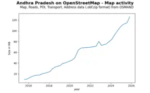
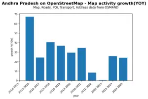
Some samples from OSMAND packaging of OSM Andhra Pradesh data (Maps, Roads,POI, transport, address) in compressed file format(.obf.zip), utilising the archived pages of OsmAnd downloads page are given in a sub page. The data is presented in the figures. There is a steady almost linear growth in the data size, except for a dip during 2021-2023. This might be because of fixes to the vandalism that happened.
An analysis of the time lapse video ( Making a time lapse video of OSM edits for more info) reveals some key milestones of mapping. Natural and principal highways, railways are already mapped by 2015. Tertiary roads start to appear from 2017. Initial villages near national highway appear around March 2017. Lot more villages appear from October 2017. Road mapping and change to roads could be seen for a long time with expanded road network around October 2020, with some grid roads updated around June 2024. Comparing with the standard OSM map used as first frame in the video, reveals that there are lot of highways in construction, which are not depicted in timelapse map. As city roads seems to have been mapped from proposed drawings of the city, actual ground/satellite image based checks are needed to reflect the true reality. When I saw an aeroplane symbol on OSM map, I checked the mapping for heliport and fixed the incorrect tag. Few grid roads do not appear linear all through. This may point to inaccuracies in mapping. Focussed activity may be needed to validate the map.
Place Mapping
Place mapping primarily done in 2018-2019 by user:adivik2000 and few other mappers using Bhuvan data (Github repo for cleaning up Bhuvan data before upload)
- Village/hamlet:34063/47745 (71.34%) [13] (Qlever query)
- Others:(town/city/suburb/neighbourhood etc): 1735/YYYY (Qlever query)
Boundaries
Administrative Boundaries
Districts, sub-districts were mapped using SOI, Bharat maps as main resources and Census 2011 maps as secondary resources by User:Heinz_V in 2019. There is maintenance required. Check the osmwiki pages and also "Check notes by Heinz for improving the boundaries and the discussion"
- Districts: 26/26 districts after reorganisation in 2022 (Qlever query)
- Mandals: 670/680 sub districts as of Dec 2025 (Qlever query for district wise counts, [https://qlever.dev/osm-planet/99asq4 Qlever query)
- Revenue Villages: 46/16500 (census 2011) (Revenue villages Qlever query) Reveue village boundaries may not align with mandal/district boundaries and are not considered legal. These are primarily used for cadastral data. Government is resurveying and creating digital maps data as of 2018-., which may align mandal/district maps after the survey is complete.
Political Boundaries
- Assembly/Parliamentary constituency boundaries: Nil
- Rural (Gram panchayat)/ Urban (Nagar panchayat, Municipality, Municipal corporation): 71/14XXX(?) (local_authorities in Andhra Pradesh)
Public Transportation
Roadways
- Total road length (not center line length) of motorway,trunk,primary, secondary,tertiary highways): number of ways:61555, Road length (one way roads considered separately)(km):91,144 (OT query)
- Total road (Primary/Secondary/Other roads) length (centerline) in the state from government sources= 133,000 km [13]
National Highways:
Extract from National highways: (OT query for map) (OT query for length (need to compute manually from the results as the difference of two lengths that are shown)
| State, or Union territory | length (km) | ||||
|---|---|---|---|---|---|
| No | Code | Name | in Morth Annual report 2024/25 |
in Morth Annual report 2022/23 |
mapped in OSM [May 2025] |
| 1 | AP | Andhra Pradesh | 8,683 | 8207 | 7783 |
- Length(km): 7296.83 (as of 27 Dec 2025) (Suspect some vandalism/inadvertent changes to tags between May and Dec 2025)
Bus stations
- Bus stations:1834/X (1792 nodes, 42 ways, 0 relations) (OT query)
Railways
- Railways in Andhra Pradesh (OT query for ways
- Railway route length: ways:5701 length(km):8,181 (OT query for length)
- Official stats for 2023-24 (Kms)
- Route kms: 4,016 Running track:7,017 Total track:8,647 [14]
- Railway stations:557/XXX (537 nodes, 19 ways, 1 relation) ([https://overpass-turbo.eu/s/2hRD OT query)
Airports
- Airports:14/X (803 nodes, 12 ways, 2 relations) (OT query)
Water resources and waterways
- Rivers: 1371 (ways/relations) (Qlever query)
- Canals: 4883 (Qlever query)
- Borewells: 76 (Qlever query)
- Sea ports: 667 nodes, 5 ways, 23 relations (OT query for port:type=seaport and industrial=port)
Amenities
The distribution of different amenities by district is shown in the gallery below. for details see the subpages.
Shop mapping is more prominent around the top urban centres namely Visakhapatnam and Vijayawada-Guntur areas. Hospital mapping is broad broadly distributed, as half of the data is an import. Pond mapping is more in districts around Visakhapatnam. MAximum fuel stations are present in Prakasam district.
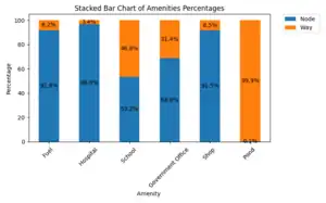
A sample of different amenities and their map representations, total counts as of December 2025 given below. It can be seen from the enclosed figure that most ponds are mapped as ways and most fuel, hospital and shops are mapped as nodes. Government offices and schools have a mix of nodes, ways.
| Amenity | Node | Way | Total |
|---|---|---|---|
| Fuel | 2187 | 195 | 2382 |
| Hospital | 4202 | 146 | 4348 |
| School | 691 | 607 | 1298 |
| Government Office | 278 | 127 | 405 |
| Shop | 5110 | 472 | 5582 |
| Pond | 22 | 20892 | 20914 |
According to google search results, the count of petrol pump(fuel) is 4441, number of schools is around 60000, and Hospitals number around 10000. So the present level of mapping for fuel stations is 54%, and for schools it is 2% and for hospitals it is about 4%. Fuel station mapping is high primarily because of import from PMGSY facilities data and concerted efforts of couple of users.
Detailed analysis for hospital amenity was done to understand the nature of data and its contributors. Only 8 users are found to be active for 3 or more years out of 16 years. There were 367 users in total who contributed. Several objects need correction in name. Only 25% of objects had seen at least one revision. For the top 80% of user contributions, 7 contributors had a share of 66% were part of import team coordinated by RMSI,[15], while 11 were general contributors accounting for 14%. Import project team had a significant contribution, though it operated mostly for 1-2 years.
Land use
- Residential: 48964 (ways) (Qlever query)
- Farm land: 5701 (Qlever query)
- Industrial: 354 (Qlever query)
- Forest: 135 (Forests spanning the border may not be captured) (Qlever query)
Special interest mapping
- Buildings:848809 (Qlever query)
- Named buildings : 6767 (Qlever query)
- Solar power plant: 124 (Qlever query)
- Wind power plant: 1 (Qlever query)
- APSRTC bus routes: 32 (Qlever query)
- Water body:22762 (Qlever query)
- Named: 3386 (Qlever query)
Name tag usage in Telugu
- All named entities:100131 (named entities using name tag Qlever query)
- Entities with name, but without name:te tag:81423 name:te missing Qlever query
- Entities with name, name:te tag: 18708 name:te usage in addition to name Qlever query
- name tag using Telugu language:108 (Qlever query) Sample OT query for way
Integration with other open platforms
For localisation of names and additional info about map objects, integration with Wikidata is useful.
Wikidata
- Entities with wikidata tag: 15114 Qlever query
Wikipedia
- Entities with either English or Telugu wikipedia tag: 6601 Qlever query
- Entities with English Wikipedia tag:864 Qlever query
- Entities with Telugu Wikipedia tag:5727 Qlever query
Mapillary
.jpg)
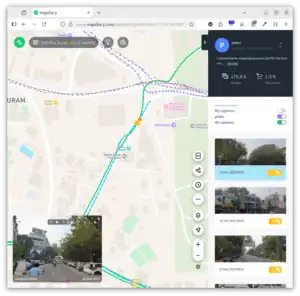
- Mapping using photos on Mapillary
Mapping resources
- Government OGDL data from SOI as web map service, (9 catalog items) posted on 27 Nov 2013
- Bharatmaps or Bharatmaps GIS portal for AP for tracing admin boundaries/verification of POI]
- AP Geo portal run by APSAC
- repo1 repo2 Mostly Open data sourced from various data sources such as SOI, Bharatmaps, PMGSY, Jal Jeevan mission etc, maintained by Sreeram K
- Bhuvan Geo portal
Maintenance
Physical world undergoes change every minute. Thus the map can never be complete and accurate. All the map data requires a continuous maintenance. Major maintenance of administrative boundaries for Andhra Pradesh were done following the bifurcation in 2014, reorganisation of districts in 2022. Minor maintenance like broken boundaries/ inadvertenty deleted objects need to be taken up atleast on an yearly basis. Tools like Osmcha, result-maps suite can help in following the map changes and also fixing errors introduced during mapping.
Quality Assessment
Academic assessment of OSM for Andhra Pradesh was not observed. Evidence of academic work related to India began to emerge in 2016. [16]
Uses
Wikipedia/Wikidata
- Number of Telugu Wikipedia pages related to Andhra Pradesh using Wikimedia maps:17287 (petscan query)
-
Video demonstrating use of Wikimedia maps in Telugu Wikipedia village articles. ( Video duration 00:01:12, Audio:Telugu)
-
 Prakasam district places in Telugu
 -
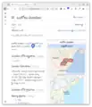 A mandal map from OpenStreetMap depicted in Telugu Wikipedia (Initiated Circa 2019)
A prominent use of OSM maps is on Telugu and English Wikipedia as a way to illustrate geographical articles to the level of mandals initiated in 2019. With the availability of Wikimedia Maps utilising OSM, more details of OSM were presented on article pages. In 2024, readers are able to interactively explore OSM via Telugu Wikipedia from most administrative geographical articles.
APSRTC Live Track
The live tracking service by APSRTC (apsrtclivetrack.com) uses OSM data via Carto's basemap. The live tracking service is also available on Android and iOS apps. The agency which developed this has also worked directly on OSM data by adding bus stops, depots, and residential areas although with severe inconsistencies. There were also instances of changing highway tags.
Ola Maps
Ola contributions to OSM started from 1 Sep 2022. It also announced its maps utilising OSM and other proprietary data in July 2024.
Projects
Non profit HOTOSM, contributed to mapping through a project to aid Andhra Pradesh 2024 flood relief. The project was coordinated by arkarjun.
Challenges & Solutions
- Most active mappers are only in single digit range. To increase their share, new contributors need to get feedback on their initial edits. Welcome message was tried with Welcome_tool and Osmcha. Rather than a generic welcome, engaging the new contributors through Osmcha with review comments and invitation to join OSM andhra telegram channel and also participate on OSM wiki might be more helpful. Active users have to spend part of their time on this activity.
- More blogging through user diaries.
- Monthly mapathons in places like Bangalore have been successful in building community. Similar activity in Vizag, Vijayawada/Guntur could be helpful.
- In addition, online events on mapping topics need to happen more frequently to engage the new users.
- Awareness of OpenStreetMap needs to be increased among the youth pursuing education and the utility of this data should get more visibility in press through projects such as flood mapping or other public service requirements.
- Academic institutions engaged in GIS should make an attempt to utilise data from OSM (for example National highways data could be as good as any commercial or state government source) for their research.
- Data sources even from government are not still available under OGDL, after the initial push in 2022. Interacting with state level policy officials could be helpful.
- User level data, discussion analysis is only available at country (India) level from Pascal Neis tools (Example: osmstats. As India is a subcontinent, data availability on a India state basis would be useful to understand the community and increase interaction.
- Annual offline event titled State of the Map - Andhra Pradesh is needed to bring together stakeholders. (SOTM Kerala could be an inspiration)
- Wide variety of tools with their own intricate query languages/ user interfaces make it difficult for contributors. AI tools could be used to get help in the form of Q&A to improve the productivity
- Amenity data maintenance with regard to name typos, tag changes need more attention. It can be easily done using Level0 editor plugin like Comfort0 of JOSM
- Duplicate mapping of objects: Needs countering with use of unique third party identifiers like Wikidata/ government_id. Need more tools to resolve these quickly.
Future Roadmap
As the independent community is very tiny, the future roadmap can not be determined at this time. This can be taken up after more offline activity to build the community.
Acknowledgements
Contributors to this article:User:Arjunaraoc,User:Ph4ni
Resources used for this article
- Github repo osm-utilities containing several jupyter notebooks for processing data
- Qlever for querying OSM data
- Overpass Turbo for querying OSM data
- Ohsome Now Stats
- ChatGPT for working with Qlever, Overpass, Wikidata queries
- Google AI, ChatGPT, Perplexity AI engines for answers for various questions about intricasies of working with OSM and related GIS tools.
References
- ↑ “Jinal Foflia, India, SotM-Asia 2017 , Country Presentation”.
- ↑ Arun Ganesh (29 April 20210). “Mapping a new way forward for Openstreetmap in India”.
- ↑ “Datameet github repo”.
- ↑ Ditty Mathew (2011-11-20). “Integrating OpenStreetMap to Wikipedia”.
- ↑ “తెలుగు_పేర్లతో_ఆంధ్రప్రదేశ్_మండలాల_సమగ్ర_భౌగోళిక_గతిశీల_పటము_విడుదల”. 2019-11-09.
- ↑ Joe Matazzoni (2018-06-28). “Interactive maps, now in your language”.
- ↑ Chaudhary, Swapnil (20 April 2021). “New mapping policy” (in en).
- ↑ “Coordinate_Me_2024_లో_పాల్గొనండి,_బహుమతులు_గెల్చుకోండి”. 2024-04-28.
- ↑ “State of the Map Asia 2018 - Day 1 - Inauguration Youtube recording”. 2 March 2019.
- ↑ “IIMB, OpenStreetMap India, and Centre for Internet and Society host ‘State of the Map Asia 2018’ Conference”. 19 November 2018.
- ↑ “Maps in Telugu Wikipedia - An Introduction; వికీపీడియాలో మ్యాపులు - ఒక పరిచయం , Youtube recording”.
- ↑ “Slide deck for " Maps in Telugu Wikipedia - An Introduction; వికీపీడియాలో మ్యాపులు - ఒక పరిచయం"”.
- ↑ 13.0 13.1 Panchayat Raj department (9 Oct 2018). “Andhra Pradesh Rural Roads Project _ Project 000063”.
- ↑ “IR Year Book 2023-24-English.pdf”. p. 60.
- ↑ “Our Experience working with Health Facilities Import -India”. 3 March 2020.
- ↑ Sukhjit Sehra et.al (2016-01-01). “Analysing OpenStreetMap data for topological errors”.