Key:symbol
 |
| Description |
|---|
| Human-readable description of route symbols that are used as waymarkers or on guideposts. In the context of road markings also used to specify symbolic road markings. |
| Group: properties |
| Used on these elements |
| Useful combination |
|
| See also |
|
|
| Status: de facto |
| Tools for this tag |
|
symbol=* is
- a human readable equivalent of
osmc:symbol=*, both describe route symbols that are used as waymarkers or on guideposts.
- See Walking Routes for country specific use of this tag.
- a tag to specify symbolic road markings
road_marking=symbol.
For route symbols
Description
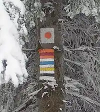
The symbol tag is used for describing symbols of hiking and other trails in a human readable form. It is usually accompanied with osmc:symbol=*, which contains a machine readable description of the symbol of the trail. Example:
symbol=red bar on white groundosmc:symbol=red:white:red_bar→
You can use international naming options in this format:
symbol=red bar ...symbol:hu=piros sáv ...
Implementing software may choose to use a local database for connecting osmc:symbol=* values to an icon or to a name, or it can choose to loud read the value of the symbol=* tag.
A routing software might say: "Turn left to the red bar and follow for two kilometers."
Examples
- Hungarian Hiking page
- WikiProject_Slovakia/Hiking_routes#Hiking_Routes_Marker_Symbols
- Symbols on guidepost:

For symbolic road markings
Use symbol=* to describe the style/form of symbolic road markings (road_marking=symbol). Use a generic term such as bicycle, pedestrian, hov (see hov=*) or airport (see also destination:symbol=*).
Examples


See also
osmc:symbol=*- Machine-Readable representation of route symbol that is used as waymarker or on guideposts.wiki:symbol=*- OpenStreetMap Wiki Symbol References of Hiking Path Symbols.information=guidepost- Used to mark a guidepost/signpost.destination:symbol=*- To indicate that a special symbol/icon is present on a signpost, visible as road marking or similar.road_marking=*- Mapping road markings.