OSM2World/Maps
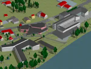
OSM2World Maps (maps.osm2world.org) was a slippy map showing an isometric rendering of OpenStreetMap data, showcasing the abilities of the OSM2World 3D renderer. It was replaced with the WebGL-based OSM2World demo.
Coverage of the map included Germany, Austria and Switzerland, plus some small regions elsewhere requested by mappers.
Software used to create the isometric tiles
- Mapsplit splits OSM extracts into data tiles
- OSM2World creates the 3D models and renders them using OpenGL to create PNGs
- Xvfb functions as an X server when working with OpenGL
- png_tilegen splits OSM2World's PNG output into tile-sized images
The service used the OSM data extracts provided by Geofabrik. Manual update requests and regions outside of the three main countries used Overpass API as the data source.
Other software
- osmfilter was used to prepare input data for Ceyx
- Ceyx, a MapCSS renderer, created the label layer according to this MapCSS style
- OpenLayers was used for tile presentation
- RRDtool created some stats
- hillshading was provided by Hike & Bike Map
See also
- Simple 3D Buildings - building tagging style supported by OSM2World
- OSM2World on Taginfo - automatically generated list of tags supported by OSM2World
- List of OSM-based services