OpenHistoricalMap/Projects/United States of Indonesia
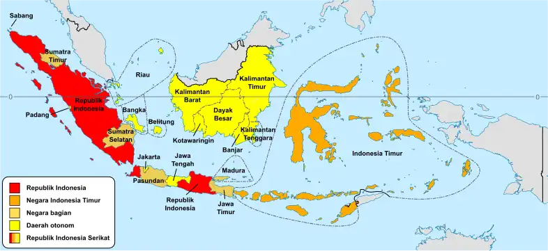
This project aims to map the Republic of the United States of Indonesia that existed briefly after independence from the Kingdom of the Netherlands from 1949 to 1950.
Territory names and designations below are taken from the Constitution of the Republic of the United States of Indonesia, except for those in italic.
Several of these constituent territories listed below contained a significant number of administrative subdivisions of their own. This especially applies to the State of the Republic of Indonesia and the State of East Indonesia. These further subdivisions are omitted here for brevity, because they have no direct relation to the federal republic. The remaining available admin_levels can be used to map them.
official_name
|
designation
|
border_type[admin_level]
|
chronology in OHM
| |
|---|---|---|---|---|
boundary=administrative
|
place=*
| |||
| republik-federasi | federal_republic[2]
|
no | no | |
a.├─ |
negara | state[4]
|
no | no |
├─ |
negara | state[4]
|
||
├─ |
negara | state[4]
|
||
│ └──Distrik Federal Djakarta[1]
|
distrik federal | federal_district[5]
|
N/A | |
├─ |
negara | state[4]
|
||
├─ |
negara | state[4]
|
||
├─ |
negara | state[4]
|
no | no |
├─ |
negara | state[4]
|
no | no |
b.├─ |
satuan kenegaraan jang tegak sendiri | territory[4]
|
||
├─ |
federatie | federation[4]
|
no | no |
│ ├──Bangka
|
satuan kenegaraan jang tegak sendiri | territory[5]
|
no | N/A |
│ ├──Belitung
|
satuan kenegaraan jang tegak sendiri | territory[5]
|
no | N/A |
│ └──Riau
|
satuan kenegaraan jang tegak sendiri | territory[5]
|
no | N/A |
├─ |
daerah istimewah | territory[4]
|
no | no |
├─ |
satuan kenegaraan jang tegak sendiri | territory[4]
|
no | no |
├─ |
satuan kenegaraan jang tegak sendiri | territory[4]
|
no | no |
├─ |
satuan kenegaraan jang tegak sendiri | territory[4]
|
no | no |
├─ |
satuan kenegaraan jang tegak sendiri | territory[4]
|
no | no |
c.├──────Kota Waringin
|
daerah jang bukan daerah-bagian | unincorporated_territory[5]
|
no | N/A |
├──────Padang
|
daerah jang bukan daerah-bagian | unincorporated_territory[5]
|
no | N/A |
└──────Sabang
|
daerah jang bukan daerah-bagian | unincorporated_territory[5]
|
N/A | |
- ↑ According to the constitution for the United States of Indonesia, the federal district is part of Negara Pasundan, yet the government of Negara Pasundan has no authority inside the federal district.
- ↑ Federation created by its constituent territories before the start of the United States of Indonesia.[1] The constitution for the United States of Indonesia only mentions the territories within.