Karaman Province
Karaman Province
Karaman ili | |
|---|---|
.jpg) Yaylapazarı, Ermenek | |
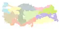
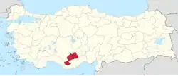 Location of the province within Turkey | |
| Country | Turkey |
| Seat | Karaman |
| Government | |
| • Governor | Hüseyin Engin Sarıibrahim |
Area | 8,678 km2 (3,351 sq mi) |
| Population (2022)[1] | 260,838 |
| • Density | 30.06/km2 (77.85/sq mi) |
| Time zone | UTC+3 (TRT) |
| Area code | 0338 |
| Website | www |
Karaman Province (Turkish: Karaman ili) is a province of south-central Turkey. Its area is 8,678 km2,[2] and its population is 260,838 (2022).[1] According to the 2000 census, the population was 243,210. The population density is 30 people/km2. The traffic code is 70. The capital is the city of Karaman. Karaman was the location of the Karamanid Beylik, which came to an end in 1486.
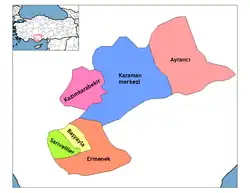
Districts and Towns
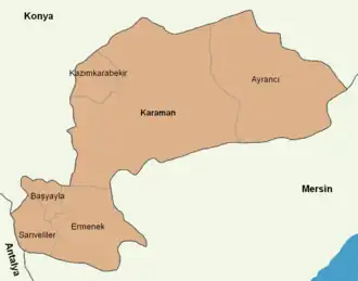
Karaman Province is divided into 6 districts:
- Ayrancı
- Başyayla
- Ermenek
- Karaman
- Kazımkarabekir
- Sarıveliler
Towns include Sudurağı, Akçaşehir, and Güneyyurt.
Place of interest
- Binbirkilise, a region around Mount Karadağ 30 km (19 mi) north of Karaman with Byzantine church ruins.
Churches
- Çeşmeli Kilise (Surp Asvadzadzin Ermeni Kilisesi)
- Fisandon Church
- Binbir Church
See also
- Görmeli, a village on the hillside of the Taurus Mountains near Ermenek
- Mount Karadağ, an extinct volcano north of Karaman city
- List of populated places in Karaman Province
Gallery
-
 Mount Karadağ
 -
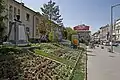 Street in Karaman
 -
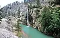 Taşeli-Plateau, Ermenek River
 -
.jpg) Yeşildere, Akköprü
Yeşildere, Akköprü -
 Yeşildere rock formation
 -
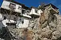 Ermenek old houses
 -
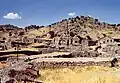 Ruins of Binbirkilise, meaning "Thousand and One Churches" in Üçkuyu
 -
.jpg) Yaylapazarı, Ermenek
Yaylapazarı, Ermenek -
_Blick_nach_S%C3%BCd.jpg) Ermenek Dam
Ermenek Dam -
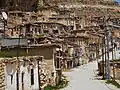 Houses in Taşkale
 -
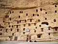 Storage caves of Taşkale are probably of ancient origin, but some may have been dug into the rock face in the post-Byzantine period.
 -
 A Yörük father with his daughter and son in Balkusan, Karaman Province
References
- ^ a b "Address-based population registration system (ADNKS) results dated 31 December 2022, Favorite Reports" (XLS). TÜİK. Retrieved 19 September 2023.
- ^ "İl ve İlçe Yüz ölçümleri". General Directorate of Mapping. Retrieved 19 September 2023.
External links
Wikimedia Commons has media related to Karaman Province.
- (in Turkish) Karaman governor's official website
- (in Turkish) Karaman municipality's official website
- (in English) Karaman weather forecast information
37°01′23″N 33°05′39″E / 37.02306°N 33.09417°E
See also
- Karaman Eyalet
| Districts |
|   | |||||||||||||||||||||||||
|---|---|---|---|---|---|---|---|---|---|---|---|---|---|---|---|---|---|---|---|---|---|---|---|---|---|---|---|
| |||||||||||||||||||||||||||
Metropolitan municipalities are bolded. | |||||||||||||||||||||||||||