Okayama Prefecture
Okayama Prefecture
岡山県 | |
|---|---|
| Japanese transcription(s) | |
| • Japanese | 岡山県 |
| • Rōmaji | Okayama-ken |
.jpg) A street in Okayama City, Okayama Prefecture at night | |
 Flag  Symbol | |
| Anthem: Okayama-ken no uta | |
 | |
| Coordinates: 34°39′42″N 133°56′5″E / 34.66167°N 133.93472°E | |
| Country | |
| Region | Chūgoku (Sanyō) |
| Island | Honshu |
| Capital | Okayama |
| Subdivisions | Districts: 10, Municipalities: 27 |
| Government | |
| • Governor | Ryūta Ibaragi |
| Area | |
• Total | 7,114.50 km2 (2,746.92 sq mi) |
| • Rank | 17th |
| Population (1 October 2025) | |
• Total | 1,815,165 |
| • Rank | 20th |
| • Density | 255.136/km2 (660.799/sq mi) |
| GDP | |
| • Total | JP¥ 7,842 billion US$ 71.9 billion (2019) |
| ISO 3166 code | JP-33 |
| Website | www |
| Symbols of Japan | |
| Bird | Lesser cuckoo (Cuculus poliocephalus) |
| Flower | Peach blossom (Prunus persica var. vulgaris) |
| Tree | Red pine (Pinus densiflora) |
Okayama Prefecture (岡山県, Okayama-ken; Japanese pronunciation: [o.kaꜜ.ja.ma, o.ka.ja.maꜜ.keɴ][2]) is a prefecture of Japan located in the Chūgoku region of Honshu.[3] Okayama Prefecture has a population of 1,815,165 (1 October 2025) and has a geographic area of 7,114 km2 (2,746 sq mi). Okayama Prefecture borders Tottori Prefecture to the north, Hyōgo Prefecture to the east, and Hiroshima Prefecture to the west.
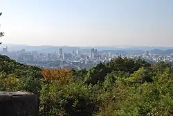
Okayama is the capital and largest city of Okayama Prefecture, with other major cities including Kurashiki, Tsuyama, and Sōja.[4][5][6] Okayama Prefecture's south is located on the Seto Inland Sea coast across from Kagawa Prefecture on the island of Shikoku, which are connected by the Great Seto Bridge, while the north is characterized by the Chūgoku Mountains.
History
Prior to the Meiji Restoration of 1868, the area of present-day Okayama Prefecture was divided between Bitchū, Bizen and Mimasaka Provinces. Okayama Prefecture was formed and named in 1871 as part of the large-scale administrative reforms of the early Meiji period (1868–1912), and the borders of the prefecture were set in 1876.[5][7]
Geography
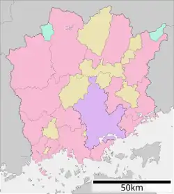
Government Ordinance Designated City City Town Village
Okayama Prefecture borders Hyōgo Prefecture, Tottori Prefecture, and Hiroshima Prefecture.[5] It faces Kagawa Prefecture in Shikoku across the Seto Inland Sea and includes 90 islands in the sea.
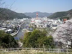
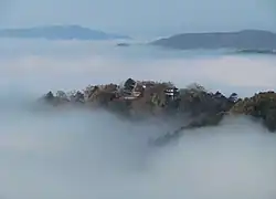
Okayama Prefecture is home to the historic town of Kurashiki. Most of the population is concentrated around Kurashiki and Okayama. The small villages in the northern mountain region are aging and declining in population - more than half of the prefecture's municipalities are officially designated as depopulated.[8]
As of 1 April 2014, 11% of the total land area of the prefecture was designated as Natural Parks, namely the Daisen-Oki and Setonaikai National Parks; the Hyōnosen-Ushiroyama-Nagisan Quasi-National Park; and seven Prefectural Natural Parks.[9]
Cities
Fifteen cities are located in Okayama Prefecture:
| Name | Area (km2) | Population | Map | |
|---|---|---|---|---|
| Rōmaji | Kanji | |||
| 赤磐市 | 209.43 | 44,498 | 
| |
| 浅口市 | 66.46 | 35,022 | 
| |
| 備前市 | 258.23 | 35,610 | 
| |
| 井原市 | 243.36 | 41,460 | 
| |
| 笠岡市 | 136.03 | 50,160 | 
| |
| 倉敷市 | 355.63 | 483,576 | 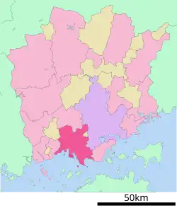
| |
| 真庭市 | 828.43 | 44,265 | 
| |
| 美作市 | 429.19 | 28,502 | 
| |
| 新見市 | 793.27 | 30,583 | 
| |
| 岡山市 | 789.92 | 720,841 | 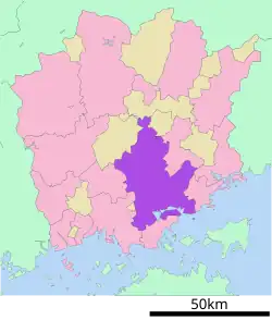
| |
| 瀬戸内市 | 125.51 | 37,934 | 
| |
| 総社市 | 212 | 67,059 | 
| |
| 高梁市 | 547.01 | 31,556 | 
| |
| 玉野市 | 103.61 | 60,101 | 
| |
| 津山市 | 506.36 | 102,294 | 
| |
Towns and villages
These are the towns and villages in each district:
| Name | Area (km2) | Population | District | Type | Map | |
|---|---|---|---|---|---|---|
| Rōmaji | Kanji | |||||
| 早島町 | 7.62 | 12,671 | Tsukubo District | Town | ||
| 鏡野町 | 419.69 | 14,651 | Tomata District | Town | 
| |
| 吉備中央町 | 268.73 | 11,989 | Kaga District | Town | 
| |
| 久米南町 | 78.65 | 4,962 | Kume District | Town | 
| |
| 美咲町 | 232.15 | 17,776 | Kume District | Town | 
| |
| 奈義町 | 69.54 | 5,861 | Katsuta District | Town | 
| |
| 西粟倉村 | 57.93 | 1,437 | Aida District | Village | 
| |
| 里庄町 | 12.23 | 11,204 | Asakuchi District | Town | 
| |
| 新庄村 | 67.1 | 951 | Maniwa District | Village | 
| |
| 勝央町 | 54.09 | 11,237 | Katsuta District | Town | 
| |
| 和気町 | 144.21 | 14,191 | Wake District | Town | 
| |
| 矢掛町 | 90.62 | 14,041 | Oda District | Town | 
| |
Mergers
Demographics
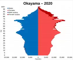
Per Japanese census data,[10] and,[11] Okayama prefecture has had continual negative population growth since 2005
| Year | Pop. | ±% |
|---|---|---|
| 1920 | 1,218,000 | — |
| 1930 | 1,284,000 | +5.4% |
| 1940 | 1,329,000 | +3.5% |
| 1950 | 1,661,000 | +25.0% |
| 1960 | 1,670,000 | +0.5% |
| 1970 | 1,707,000 | +2.2% |
| 1980 | 1,871,000 | +9.6% |
| 1990 | 1,926,000 | +2.9% |
| 2000 | 1,950,828 | +1.3% |
| 2010 | 1,945,276 | −0.3% |
| 2020 | 1,920,739 | −1.3% |
Education
Universities
- Okayama
- Notre Dame Seishin University
- Okayama Shoka University
- Okayama University
- Okayama University of Science
- Sanyo Gakuen University
- Shujitsu University
- Shujitsu Junior College
- Kurashiki
- Kawasaki University of Medical Welfare
- Kurashiki Sakuyo University
- Okayama Gakuin University
- Soja
- Okayama Prefectural University
- Tsuyama
- Mimasaka University
- Niimi
- Niimi Public University
High schools
- Okayama
- Kurashiki High School
- Okayama Asahi Senior High School
- Okayama Takahashi High School
- Okayama Ichinomiya Senior High School
- Okayama Hosen Senior High School
- Okayama Joto Senior High School
- Okayama Sakuyo High School[12]
- Okayama Sozan Senior High School
Transportation
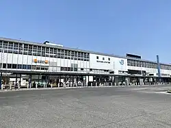
.jpg)
Rail
- JR West
- Ako Line
- Geibi Line
- Inbi Line
- Hakubi Line
- Kibi Line
- Kishin Line
- Sanyo Shinkansen
- Sanyo Line
- Tsuyama Line
- Uno Line
- JR West and JR Shikoku
- Honshi-bisan Line
- Seto-Ōhashi Line
- Chizu Express
- Ibara Railway
- Mizushima Rinkai Railway
Tramways
- Okayama Electric Tramway
Roads
Expressways
- Chugoku Expressway
- Okayama Expressway
- Sanyo Expressway
- Seto Central Expressway
- Tottori Expressway
- Yonago Expressway
National highways
- Route 2 (Osaka-Kobe-Himeji-Bizen-Okayama-Kurashiki-Asakuchi-Onomichi-Hiroshima-Shūnan-Shimonoseki-Kitakyushu)
- Route 30 (Okayama-Uno-Takamatsu
- Route 53 (Okayama-Tsuyama-Tottori)
- Route 179
- Route 180 (Okayama-Takahashi-Niimi)
- Route 181 (Tsuyama-Maniwa-Yonago-Yasugi-Matsue)
- Route 182
- Route 183
- Route 250 (Okayama-Setouchi-Ako-Aioi-Takasago-Akashi)
- Route 313 (Fukuyama-Takahashi-Maniwa-Kurayoshi)
- Route 373
- Route 374
- Route 429
- Route 430
- Route 482 (Kyotango-Toyooka-Wakasa-Kagamino-Maniwa-Kōfu of Tottori
- Route 484
Airport
- Okayama Airport
Culture
- Bizen-yaki (Bizen pottery)
- Bizen Osafune/Bitchu Aoe swords
Association with Momotarō legend
Okayama Prefecture is closely associated with the folklore hero, Momotarō. This tale is said to have roots in the legendary story of Kibitsuhiko-no-mikoto and Ura which explains that the Prince Ura of Kudara used to live in Kinojo (castle of the devil) and was a cause of trouble for the people living in the village. The emperor's government sent Kibitsuhiko-no-mikoto (Momotarō) to defeat Ura. The city of Okayama holds an annual Momotarō-matsuri, or Momotarō Festival.[6][13]
Arts
- Inryoji Temple
- Hayashibara Museum of Art
- Okayama Orient Museum
- Okayama Prefectural Museum
- Okayama Prefectural Museum of Art
- Okayama Symphony Hall
- Yumeji Art Museum
Sports
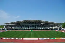
The sports teams listed below are based in Okayama.
Football
- Fagiano Okayama FC (Okayama city)
- Mitsubishi Motors Mizushima FC (Kurashiki)
Volleyball
- Okayama Seagulls (Okayama city)
Basketball
- Tryhoop Okayama (B3 League, Okayama city)
Tourism
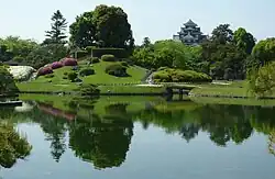
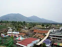

Some tourist attractions are:
- Bikan Historical Area (倉敷美観地区, Kurashiki Bikan Chiku), Kurashiki
- Bisei Astronomical Observatory (美星天文台, Bisei Tenmondai), Ibara Town (following dissolution of Bisei Town)
- Bitchu Matsuyama Castle, Takahashi
- Brazilian Park Washuzan Highland, Kurashiki
- Kakuzan Park, Tsuyama
- Koraku-en Japanese garden in Okayama
- Ki Castle, Sōja
- Maki-do Cave, in Niimi
- Ohara Museum of Art, Kurashiki
- Okayama Castle, Okayama
- Shizutani School, Bizen
Notable people
- Yuko Arimori (born 1966), marathon runner[14]
- Kenji Doihara (1883–1948), army officer
- Tesshō Genda (born 1948), voice actor
- Morihiro Hashimoto (1977–2017), darts player
- Naoki Hoshino (1892–1978), politician
- Koshi Inaba (born 1964), singer
- Masaki Kajishima (born 1962), creator of Tenchi Muyo!
- Shiro Kawase (1889–1946), admiral
- Sadahiko Miyake (1891–1956), general
- Chiura Obata (1885–1975), artist
- Mori Takashi, former member of Gentouki
- Yōji Takikawa (born 1949), pedagogist
- Mutsuo Toi (1917–1938), perpetrator of the Tsuyama massacre
- Inukai Tsuyoshi (1855–1932), former Prime Minister of Japan
- Jiro Watanabe (born 1955), boxer
- Takeo Yasuda (1889–1964), lieutenant general
- Eisuke Yoshiyuki (1906–1940), author
- Fujii Kaze (born 1997), singer
- Nishimura Riki, also known as Ni-ki of ENHYPEN (born 2005), K-pop idol,[15] dancer, singer, rapper
- Issei Mamehara (born 2002), singer, dancer, member of JO1
Notes
- ^ "2020年度国民経済計算(2015年基準・2008SNA) : 経済社会総合研究所 - 内閣府". 内閣府ホームページ (in Japanese). Archived from the original on 24 September 2023. Retrieved 18 May 2023.
- ^ NHK Broadcasting Culture Research Institute, ed. (24 May 2016). NHK日本語発音アクセント新辞典 (in Japanese). NHK Publishing.
- ^ Nussbaum, Louis-Frédéric. (2005). "Okayama-ken" in Japan Encyclopedia, p. 745, p. 745, at Google Books; "Chūgoku" at p. 127, p. 127, at Google Books.
- ^ Nussbaum, "Okayama" at p. 745, p. 745, at Google Books.
- ^ a b c "Okayama Prefecture". Encyclopedia of Japan. Tokyo: Shogakukan. 2012. OCLC 56431036. Archived from the original on 25 August 2007. Retrieved 1 August 2012.
- ^ a b "岡山(県)" [Okayama Prefecture]. Nihon Daihyakka Zensho (Nipponika) (in Japanese). Tokyo: Shogakukan. 2012. OCLC 153301537. Archived from the original on 25 August 2007. Retrieved 15 August 2012.
- ^ Nussbaum, "Provinces and prefectures" at p. 780, p. 780, at Google Books.
- ^ Okayama official website Archived 2 January 2013 at the Wayback Machine accessed November 2007
- ^ "General overview of area figures for Natural Parks by prefecture" (PDF). Ministry of the Environment. 1 April 2014. Archived (PDF) from the original on 21 April 2012. Retrieved 19 February 2015.
- ^ "Okayama (Japan): Prefecture, Major Cities & Towns - Population Statistics, Maps, Charts, Weather and Web Information". www.citypopulation.de. Archived from the original on 2022-05-12. Retrieved 2022-05-12.
- ^ "Japan Prefectures Population from 1920 and Area". www.demographia.com. Archived from the original on 2017-04-29. Retrieved 2020-11-25.
- ^ "岡山県作陽高等学校". www.sakuyo-h.ed.jp. Archived from the original on 11 January 2018. Retrieved 24 April 2018.
- ^ "Okayama History". Archived from the original on 22 May 2012. Retrieved 24 June 2012.
- ^ "Yuko Arimori's profile". Archived from the original on 2015-06-17. Retrieved 2013-05-31.
- ^ "ENHYPEN's profile". Archived from the original on 2022-08-10. Retrieved 2024-01-28.
References
- Nussbaum, Louis-Frédéric and Käthe Roth (2005). Japan Encyclopedia. Cambridge: Harvard University Press. ISBN 978-0-674-01753-5; OCLC 58053128.
External links
- Official website
- Official tourism site
- Official account's channel on YouTube
 Geographic data related to Okayama Prefecture at OpenStreetMap
Okayama (capital) | ||||
| Okayama |
| |||
| Core city | ||||
| Cities |
| |||
| Districts |
| |||
List of mergers in Okayama Prefecture | ||||