Washington–Baltimore combined statistical area
Washington–Baltimore combined statistical area | ||
|---|---|---|
Combined Statistical Area | ||
| Washington–Baltimore–Arlington, DC–VA–MD–WV–PA Combined Statistical Area | ||
Interactive Map of Washington–Baltimore–Arlington, DC–VA–MD–WV–PA CSA
| ||
| Coordinates: 38°58′N 77°19′W / 38.97°N 77.32°W | ||
| Country | United States | |
| State or area | ||
| Constituent metropolitan & micropolitan areas | Core areas:
Outlying areas:
| |
| Principal cities |
| |
| Population (2023) | ||
| • CSA | 10,069,592 (3rd) | |
| GDP | ||
| • CSA | $941.502 billion (2022) | |
| Time zone | UTC-5 (EST) | |
| • Summer (DST) | UTC-4 (EDT) | |
| Area codes | 202/771, 301/240/227, 304/681, 410/443/667, 540/826, 703/571, 717/223 | |
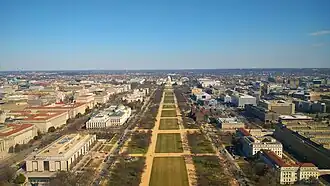


The Washington–Baltimore combined metropolitan statistical area is a statistical area, including the overlapping metropolitan areas of Washington, D.C. and Baltimore. The region includes Central Maryland, Northern Virginia, three counties in the Eastern Panhandle of West Virginia, and one county in south-central Pennsylvania. It is the most educated, highest-income, and third-most populous combined statistical area in the United States behind New York City–Newark, NJ and Los Angeles–Long Beach.[2][3]
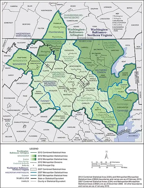
The area is designated by the Office of Management and Budget (OMB) as the Washington–Baltimore–Arlington, DC–MD–VA–WV–PA Combined Statistical Area. It is composed primarily of two major metropolitan statistical areas (MSAs), the Washington–Arlington–Alexandria, DC–VA–MD–WV MSA and the Baltimore–Columbia–Towson, Maryland Metropolitan Statistical Area. Five smaller urban areas not contiguous to the main urban area but having strong commuting ties with the main area are included in the metropolitan area:[4]Hagerstown–Martinsburg, Maryland–West Virginia MSA, the Chambersburg–Waynesboro, Pennsylvania MSA, the Winchester, VA–WV MSA, the California–Lexington Park, Maryland MSA, and the Easton, Maryland micropolitan statistical area (μSA).
Some counties, such as Caroline and King George County, Virginia, are not officially designated by OMB as members of this metropolitan area but still consider themselves members anyway.[5][6][7][8][9] This is mostly due to their proximity to the area, the size of their commuter population, and by the influence of local broadcasting stations. The population of the entire Washington–Baltimore Combined Statistical Area as of the 2020 census was 9,973,383. The area's most-populous city is Washington, D.C. with a population of 689,545, and the area's most populous county is Fairfax County, Virginia, with a population of 1,150,309.[10]
Components of the combined statistical area
The counties and independent cities and their groupings that comprise the area are listed below with their 2012 population estimates. Central counties/cities (designated as such by OMB) for each MSA are shown in italics.
- Washington–Arlington–Alexandria, DC–VA–MD–WV Metropolitan Area (5,860,342)
- Arlington–Alexandria–Reston, VA–WV Metropolitan Division
- Arlington County, Virginia
- Clarke County, Virginia
- Culpeper County, Virginia
- Fairfax County, Virginia
- Fauquier County, Virginia
- Loudoun County, Virginia
- Prince William County, Virginia
- Rappahannock County, Virginia
- Spotsylvania County, Virginia
- Stafford County, Virginia
- Warren County, Virginia
- Alexandria, Virginia
- Fairfax, Virginia
- Falls Church, Virginia
- Fredericksburg, Virginia
- Manassas, Virginia
- Manassas Park, Virginia
- Jefferson County, West Virginia
- Frederick–Gaithersburg–Bethesda, MD Metropolitan Division (1,244,291)
- Washington, DC–MD Metropolitan Division (4,616,051)
- Arlington–Alexandria–Reston, VA–WV Metropolitan Division
- Baltimore–Columbia–Towson, MD Metropolitan Area (2,753,149)
- Baltimore City
- Anne Arundel County
- Baltimore County
- Carroll County
- Harford County
- Howard County
- Queen Anne's County
- Hagerstown–Martinsburg, MD–WV Metropolitan Area (256,278)
- Washington County, Maryland
- Berkeley County, West Virginia
- Morgan County, West Virginia
- Chambersburg, PA Metropolitan Area (151,275)
- Franklin County, Pennsylvania
- Winchester, VA–WV Metropolitan Area (130,907)
- Frederick County, Virginia
- Winchester city, Virginia
- Hampshire County, West Virginia
- California–Lexington Park, MD Metropolitan Area (108,987)
- Easton, MD Micropolitan Area (38,098)
- Talbot County, Maryland
- Lake of the Woods, VA Micropolitan Area
- Orange County, Virginia
- Cambridge, MD Micropolitan Area
- Dorchester County, Maryland
Regional organizations
Metropolitan Washington Council of Governments
Founded in 1957, the Metropolitan Washington Council of Governments (MWCOG) is a regional organization of 23 Washington-area local governments, members of the Maryland and Virginia state legislatures, the U.S. Senate, and the U.S. House of Representatives. MWCOG provides a forum for discussion and the development of regional responses to issues regarding the environment, transportation, public safety, homeland security, affordable housing, community planning, and economic development.[11]
The National Capital Region Transportation Planning Board, a component of MWCOG, is the federally designated Metropolitan Planning Organization for the metropolitan Washington area.[12]
Baltimore Metropolitan Council
The Baltimore Metropolitan Council is the equivalent organization for the Baltimore portion of the combined Baltimore–Washington metropolitan area.[13] The BMC, which was created in 1992 as the successor to the Regional Planning Council and Baltimore Regional Council of Governments, consists of the Baltimore region's elected executives, representing Baltimore City and Anne Arundel, Baltimore, Carroll, Harford and Howard counties.[14]
The Baltimore Regional Transportation Board is the federally recognized Metropolitan Planning Organization for transportation planning in the Baltimore region.[14]
Principal cities
Major cities
- Baltimore, Maryland
- Washington, D.C.
Baltimore area
- Baltimore
- Aberdeen, Maryland
- Annapolis, Maryland
- Arbutus, Maryland
- Bel Air, Maryland
- Brooklyn, Maryland
- Brooklyn Park, Maryland
- Catonsville, Maryland
- Cockeysville, Maryland
- Columbia, Maryland
- Curtis Bay, Maryland
- Dundalk, Maryland
- Eldersburg, Maryland
- Elkridge, Maryland
- Ellicott City, Maryland
- Essex, Maryland
- Fullerton, Maryland
- Glen Burnie, Maryland
- Halethorpe, Maryland
- Linthicum, Maryland
- Lutherville-Timonium, Maryland
- Middle River, Maryland
- North Laurel, Maryland
- Owings Mills, Maryland
- Overlea, Maryland
- Parkville, Maryland
- Pasadena, Maryland
- Perry Hall, Maryland
- Pikesville, Maryland
- Randallstown, Maryland
- Reisterstown, Maryland
- Savage, Maryland
- Severna Park, Maryland
- Towson, Maryland
- Westminster, Maryland
- Woodlawn, Maryland
Washington, D.C. area
- Washington, D.C.
- Bethesda, Maryland
- Bowie, Maryland
- Chevy Chase, Maryland
- College Park, Maryland
- Frederick, Maryland
- Gaithersburg, Maryland
- Germantown, Maryland
- Greenbelt, Maryland
- Laurel, Maryland
- Potomac, Maryland
- Rockville, Maryland
- Silver Spring, Maryland
- Upper Marlboro, Maryland
- Alexandria, Virginia
- Annandale, Virginia
- Arlington, Virginia
- Ashburn, Virginia
- Chantilly, Virginia
- Fairfax, Virginia
- Falls Church, Virginia
- Fredericksburg, Virginia
- Great Falls, Virginia
- Herndon, Virginia
- Langley, Virginia
- Leesburg, Virginia
- Manassas, Virginia
- Manassas Park, Virginia
- Massaponax, Virginia
- McLean, Virginia
- Mt. Vernon, Virginia
- Reston, Virginia
- Springfield, Virginia
- Tysons, Virginia
- Vienna, Virginia
Outlying areas
- California, Maryland
- Cambridge, Maryland
- Centreville, Maryland
- Easton, Maryland
- Frederick, Maryland
- Hagerstown, Maryland
- Hancock, Maryland
- Lexington Park, Maryland
- Thurmont, Maryland
- Chambersburg, Pennsylvania
- McConnellsburg, Pennsylvania
- Waynesboro, Pennsylvania
- Culpeper, Virginia
- Warrenton, Virginia
- Winchester, Virginia
- Charles Town, West Virginia
- Martinsburg, West Virginia[16]
Economy
Primary industries
Biotechnology
Maryland's Washington suburbs are a major center for biotechnology. Prominent local biotechnology companies include MedImmune, United Therapeutics, The Institute for Genomic Research, Human Genome Sciences, and the Howard Hughes Medical Institute.
Defense contracting
Many defense contractors are based in Northern Virginia and Montgomery County, Maryland to be close to the Pentagon in Arlington. Local defense contractors include Lockheed Martin, the largest, as well as Northrop Grumman, General Dynamics, BAE Systems Inc., Computer Sciences Corporation (CSC), Booz Allen Hamilton, Leidos, Science Applications International Corporation (SAIC), Orbital Sciences Corporation, and AAI Corporation.
Notable company headquarters in the region
Numbers denote Fortune 500 ranking.
Maryland
Baltimore area:
- AAI Corporation (Hunt Valley)
- Advertising.com (Baltimore)
- Allegis Group (Hanover)
- Black & Decker (Towson)
- Ciena Corporation (Hanover)
- Colfax Corporation (Annapolis Junction)
- Constellation Energy (Baltimore)
- Corporate Office Properties Trust (Columbia)
- The Cordish Companies (Baltimore)
- CoverGirl (Hunt Valley)
- Fila USA (Sparks)
- Firaxis Games (Sparks)
- First Friday's Group (Baltimore)
- Legg Mason (Baltimore)
- McCormick & Company (Hunt Valley) 482
- MICROS Systems (Columbia)
- Millennial Media (Baltimore)
- Nielsen Audio (Columbia)
- Pandora Jewelry USA (Baltimore)
- T. Rowe Price (Baltimore) 447
- Transamerica Corporation (Baltimore)
- Sinclair Broadcast Group (Hunt Valley) 465
- Sourcefire (Columbia)
- Sylvan Learning (Baltimore)
- Under Armour (Baltimore)
- W.R. Grace & Co. (Columbia)
- The Whiting-Turner Contracting Company (Towson)[17]
Washington area:
- 2U (company) (Lanham, Maryland)
- ASRC Aerospace Corporation (Greenbelt, Maryland)
- Bethesda Softworks (Rockville)
- Clark Construction (Bethesda)
- Choice Hotels (Rockville)
- Coventry Health Care (Bethesda)
- EagleBank (Bethesda)
- Enviva (Bethesda)
- Federal Realty Investment Trust (Rockville)
- GEICO (Chevy Chase)
- Host Hotels & Resorts (Bethesda) 472
- Hughes Network Systems (Germantown)
- Inovalon (Bowie, Maryland)
- JBG Smith (Chevy Chase)
- Lockheed Martin (Bethesda) 49
- Marriott International (Bethesda) 293
- MedImmune (Gaithersburg)
- New Enterprise Associates (Chevy Chase)
- Novavax (Gaithersburg)
- Radio One (Lanham)
- Ritz-Carlton (Chevy Chase)
- Travel Channel (Chevy Chase)
- TV One (Silver Spring)
- United Therapeutics (Silver Spring)
Northern Virginia
- AES Corporation (Arlington) 194
- Amazon (Crystal City)
- Appian Corporation (Tysons Corner)
- AvalonBay Communities (Arlington)
- Airbus North America (Herndon)
- BAE Systems Inc. (Arlington)
- Bechtel (Reston)
- Bloomberg Industry Group (Arlington)
- Boeing (Arlington) 58[18]
- Booz Allen Hamilton (McLean) 481
- CACI (Arlington)
- Capital One (McLean) 100
- Carfax (Centreville, Virginia)
- Computer Sciences Corporation (Falls Church) 379
- Communications Satellite Corporation (Herndon)
- Comscore (Reston)
- Cvent (Tysons Corner)
- DynCorp International (Falls Church)
- Freddie Mac (McLean) 39
- FNH USA (Fredericksburg)
- FLIR Systems Government and Defense (Arlington)
- Graham Holdings (Arlington)
- Gannett Company (McLean)
- General Dynamics (Falls Church) 90
- GTT Communications (Tysons Corner)
- Hilton Hotels Corporation (McLean) 241
- ICF International (Fairfax)
- Iridium Communications (McLean)
- Stride, Inc. (Herndon)
- Kellogg Brown and Root Services (Arlington)
- Leidos (Reston) 381
- Ligado Networks (Reston)
- Mars, Incorporated (McLean)
- M.C. Dean, Inc. (Dulles)
- MicroStrategy (Tysons Corner)
- Naviance (Arlington)
- Navy Federal Credit Union (Vienna)
- NII Holdings (Reston)
- Northrop Grumman (Falls Church) 114
- NVR Incorporated (Reston) 446
- Orbital Sciences (Dulles)
- Park Hotels & Resorts (Tysons Corner)
- Parsons Corporation (Centreville)
- Rolls-Royce North America (Reston)
- Rosetta Stone (Arlington)
- Science Applications International Corporation (McLean)
- SLM Corporation (Reston) "Sallie Mae"
- Strategic Education, Inc. (Herndon)
- Space Adventures (Vienna)
- Tegna Inc. (Tysons Corner)
- The Motley Fool (Alexandria, Virginia)
- The Teaching Company (Chantilly)
- Verisign (Reston)
- Verizon Business (Ashburn)
- Volkswagen Group of America (Herndon)
- VSE Corporation (Alexandria, Virginia)
- XO Communications (Herndon)
Washington, D.C.
- &pizza
- APCO Worldwide
- Atlantic Media
- Black Entertainment Television
- Blackboard Inc.
- Bluemercury
- Carlyle Group
- Chemonics
- Cogent Communications
- CoStar Group
- Danaher Corporation 239
- Fannie Mae 53
- FiscalNote
- Framebridge
- Gallup
- Mapbox
- Morning Consult
- National Geographic Society
- NGP VAN
- Pepco Holdings 279
- Social Tables
- The Washington Post Company
- Vox Media
- XM Satellite Radio
Sports

Table of professional teams and venues
| Club | Sport | League | Founded | Venue |
|---|---|---|---|---|
| Washington Capitals | Hockey | NHL | 1974 | Capital One Arena |
| Washington Nationals | Baseball | MLB | 2005[a] | Nationals Park |
| Baltimore Orioles | Baseball | MLB | 1954[a] | Oriole Park at Camden Yards |
| Washington Wizards | Basketball | NBA | 1973[a] | Capital One Arena |
| Baltimore Ravens | Football | NFL | 1996 | M&T Bank Stadium |
| Washington Commanders | Football | NFL | 1937[a] | Northwest Field |
| D.C. United | Soccer | MLS | 1996 | Audi Field |
| Washington Mystics | Basketball | WNBA | 1998 | CareFirst Arena |
| Washington Spirit | Soccer | NWSL | 2011[b] | Maryland SoccerPlex (primary) Audi Field (secondary) Segra Field (secondary) |
| Maryland Whipsnakes | Lacrosse | PLL | 2019 | Homewood Field |
Transportation


_from_the_overpass_for_Virginia_State_Route_796_(Oak_Street)_on_the_edge_of_Idylwood_and_Dunn_Loring_in_Fairfax_County%252C_Virginia.jpg)

Commercial airports
| Airport | IATA code | ICAO code | County | State | Note |
|---|---|---|---|---|---|
| Baltimore/Washington International Airport | BWI | KBWI | Anne Arundel County | Maryland | The closest airport to Baltimore and region's busiest[19] airport |
| Dulles International Airport | IAD | KIAD | Loudoun County | Virginia | Most international traffic in region |
| Hagerstown Regional Airport | HGR | KHGR | Washington County | Maryland | Serves Western Maryland, the Eastern Panhandle of West Virginia, and portions of south-central Pennsylvania and northwestern Virginia along the Interstate 81 corridor |
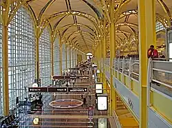
| Ronald Reagan Washington National Airport | DCA | KDCA | Arlington County | Virginia | Region's second-busiest[19] airport and its closest airport to Washington, D.C. |
Rail transit systems
Intercity Rail
Commuter/Regional Rail
- MARC Train
- Virginia Railway Express
Heavy Rail Subway
- Washington Metro
- Baltimore Metro SubwayLink
Light Rail
- Baltimore Light RailLink
- DC Streetcar (until 2026)[20]
- Purple Line (under construction; projected opening 2027)
Major highways
Interstates
 Interstate 66
 Interstate 70
 Interstate 81
 Interstate 83
 Interstate 95
 Interstate 97
 Interstate 195
 Interstate 270
 Interstate 295
 Interstate 370
 Interstate 395 (District of Columbia-Virginia)
- Interstate 395 (Maryland)
 Interstate 495 (Capital Beltway)
 Interstate 595 (Unsigned)
 Interstate 695 (District of Columbia)
- Interstate 695 (Baltimore Beltway)
 Interstate 795
 Interstate 895
U.S. Routes
 U.S. Route 1
 U.S. Route 11
 U.S. Route 15
 U.S. Route 29
 U.S. Route 40
 U.S. Route 50
 U.S. Route 301
 U.S. Route 340
State Routes
 District of Columbia Route 295[note 1] (Anacostia Freeway)
 Maryland Route 2
 Maryland Route 4
 Maryland Route 5
 Maryland Route 26
 Maryland Route 32
 Maryland Route 97
 Maryland Route 100
 Maryland Route 200 (Intercounty Connector)
 Maryland Route 410 (East-West Highway)
 Baltimore–Washington Parkway[note 2] (Maryland Route 295)
 Maryland Route 355
 Virginia State Route 3
 Virginia State Route 7
 Virginia State Route 9
 Virginia State Route 28
 Virginia State Route 267
 Virginia State Route 286 (Fairfax County Parkway)
 Virginia State Route 289 (Franconia–Springfield Parkway)
 West Virginia Route 9
See also
- Beltway Series
- List of parks in the Baltimore–Washington metropolitan area
- National Capital Region
- United States metropolitan area
Notes
References
- ^ "Gross Domestic Product by County and Metropolitan Area". Federal Reserve Economic Data. Federal Reserve Bank of St. Louis.
- ^ "CSA Median household income". Greaterbaltimore.org. Archived from the original on 7 December 2012. Retrieved 16 November 2017.
- ^ "Raleigh-Durham area ranks third in U.S. for college degrees". Triangle.bizjournals.com. Retrieved 16 November 2017.
- ^ "OMB BULLETIN NO. 18-04: Revised Delineations of Metropolitan Statistical Areas, Micropolitan Statistical Areas, and Combined Statistical Areas, and Guidance on Uses of the Delineations of These Areas". Office of Management and Budget. September 14, 2018.
- ^ "Caroline County Economic Development". Archived from the original on 2015-07-11. Retrieved 2015-07-21.
- ^ "Washington DC South". washingtondcsouth.com. Retrieved 16 November 2017.
- ^ "King George County Department of Economic Development". King George County Department of Economic Development. Retrieved 16 November 2017.
- ^ Gardner, D'Vera Cohn and Amy (16 March 2006). "3 Virginia Exurbs Near Top of U.S. in Growth". Washingtonpost.com. Retrieved 16 November 2017.
- ^ "FAMPO Technical Committee – FAMPO". Fampo.gwregion.org. Retrieved 16 November 2017.
- ^ "2020 Population and Housing State Data". U.S. Census Bureau. August 12, 2021. Retrieved September 5, 2021.
- ^ "COG & Our Region - Metropolitan Washington Council of Governments". Mwcog.org. Retrieved 16 November 2017.
- ^ "Transportation Planning Board - Transportation - Metropolitan Washington Council of Governments". Mwcog.org. Retrieved 16 November 2017.
- ^ O'Leary, __Sara Ann. "Home - Baltimore Metropolitan Council". Baltometro.org. Retrieved 16 November 2017.
- ^ a b About BMC – Baltimore Metropolitan Council Archived 2007-05-01 at the Wayback Machine
- ^ "U.S. Census Bureau – Principal cities of metropolitan and micropolitan statistical areas". Census.gov. Retrieved 16 November 2017.
- ^ "Metropolitan And Micropolitan Statistical Areas And Principal Cities, November 2007, with codes". Census.gov. Retrieved 16 November 2017.
- ^ "Whiting-Turner Contracting on the Forbes America's Largest Private Companies List". Forbes.com. Retrieved 16 November 2017.
- ^ "The Boeing Company: General Information". www.boeing.com. Retrieved 2023-07-31.
- ^ a b "Final CY23 Enplanements at All Commercial Service Airports" (PDF). 2 October 2024.
- ^ Weiner, Rachel (9 Oct 2025). "Budget cut means D.C. Streetcar will shut down in March". The Washington Post. Archived from the original on 9 Oct 2025. Retrieved 20 Oct 2025.
| Topics |
|
|---|---|
| Government |
|
| Services |
|
| Society |
|
| History |
|
| |
Annapolis (capital) | |
| Topics |
|
| Society |
|
| Regions |
|
| CDPs |
|
| Counties |
|
Commonwealth of Virginia | |
|---|---|
Richmond (capital) | |
| Topics |
|
| Culture |
|
| Regions |
|
| Metro areas |
|
| Independent cities |
|
Charleston (capital) | |
| Topics |
|
| Society |
|
| Insignia |
|
| Regions |
|
| Metro areas |
|
| Cities with over 15,000 residents |
|
| Counties |
|
Commonwealth of Pennsylvania | |
|---|---|
Harrisburg (capital) | |
| Topics |
|
| Society |
|
| Metro areas |
|
| Regions |
|
| Counties |
|